search
Via Dolorosa map
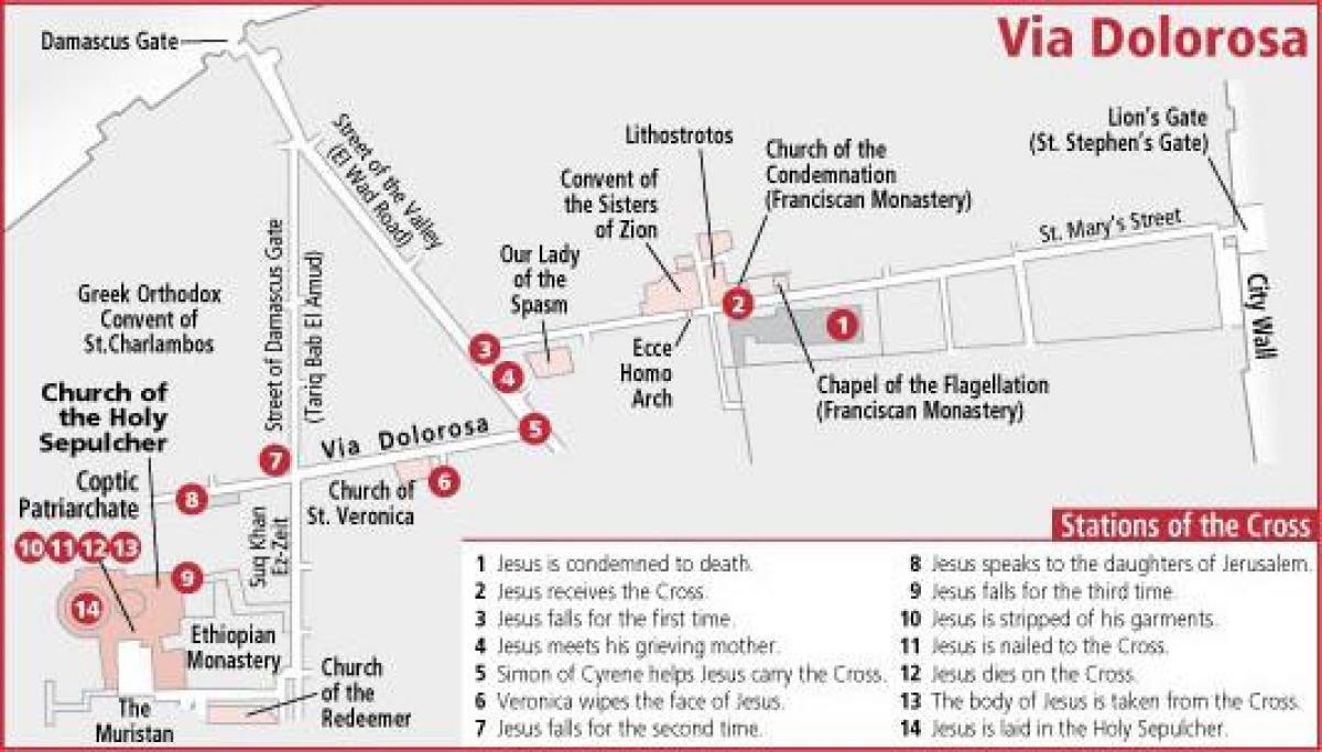
Map of via Dolorosa. Via Dolorosa map (Israel) to print. Via Dolorosa map (Israel) to download. Via Dolorosa (Latin for “Sorrowful Way” or “Way of Suffering”) is a route through the Old City of Jerusalem that is believed to be the path Jesus walked to his crucifixion. The route goes from Antonia Fortress to the Church of the Holy Sepulchre, a distance of about 600 meters, and is a celebrated place of Christian pilgrimage as you can see in the via Dolorosa map. The route was established in the 18th century. Today it is marked by the 14 Stations of the Cross, the final five stations of which are located inside the Church of the Holy Sepulchre. Via Dolorosa is not a street but a route. After eating with his disciples at The Last Supper, Jesus went to Gethsemane. He was caught and surrendered to the Romans who sentenced him to die by crucifixion. The route Jesus took from the place of his judgment to the site of his crucifixion on Mount Calvary is sacred in Christianity. This final and fateful route is the Via Dolorosa.
Fourteen stations along this path signify events mentioned in the New Testament and Christian tradition, and different Christian denominations emphasize certain traditions and stations over others as its shown in the via Dolorosa map. For most pilgrims, the exact location of the events is of little importance compared to the deep meaning the route holds and its proximity to the original events. Pilgrims stop at each of the 14 Stations of the Cross for prayer and reflection. The current route of the Via Dolorosa was established in the 18th century based on the events of Jesus’ crucifixion in the 1st century CE, but the significance for believers crosses the boundaries of time and space. The Via Dolorosa provides a unique atmosphere and experience in Old Jerusalem.
It was here in the Via Dolorosa on Passover week; where the Romans forced Simon of Cyrene to carry the cross (Mark 15:21). There are fourteen traditional stations marked. The first is the Praetorium, where Pontius Pilate condemned Jesus and Jesus took up the cross (Mark 15:15), and where now you will find a convent. In the basement you will find flagstones, known as Gabata (John 19:13), stone pavements. Beneath this pavement is a large water cistern built by Herod the Great, which could have quenched the thirsty Roman soldiers who taunted Jesus (Matt. 27: 27-31) as its mentioned in the via Dolorosa map. Christian visitors on their holy land tours find the Stations of the Cross only modestly marked. Continuing after the Praetorium you will find station three, where Jesus fell with his cross; which mentioned in the new testament this recurred two more times. In the fourth station is where Simon takes up the cross.


