
search
City of David map
Map of city of David. City of David map (Israel) to print. City of David map (Israel) to download. The City of David - another term for the Jerusalem of ancient times - was located on a narrow ridge south of the present-day Old City. It borders the deep Kidron Valley to the East, where the Gihon Spring, the city main water source, is located as you can see in the city of David map. The archeological exploration of the City of David began in the middle of the 19th century and continues to this day. It has fired the imagination of many scholars from different nations and backgrounds who came to excavate in Jerusalem. The latest excavations were carried out between 1978 and 1985 and there is an ongoing process of updating and revising previous interpretations. The earliest permanent settlement uncovered is represented by several rectangular buildings with benches along their interior walls. These buildings, dated to the Early Bronze Age (3rd millennium BCE) are typical of Canaanite urban settlements at that time.
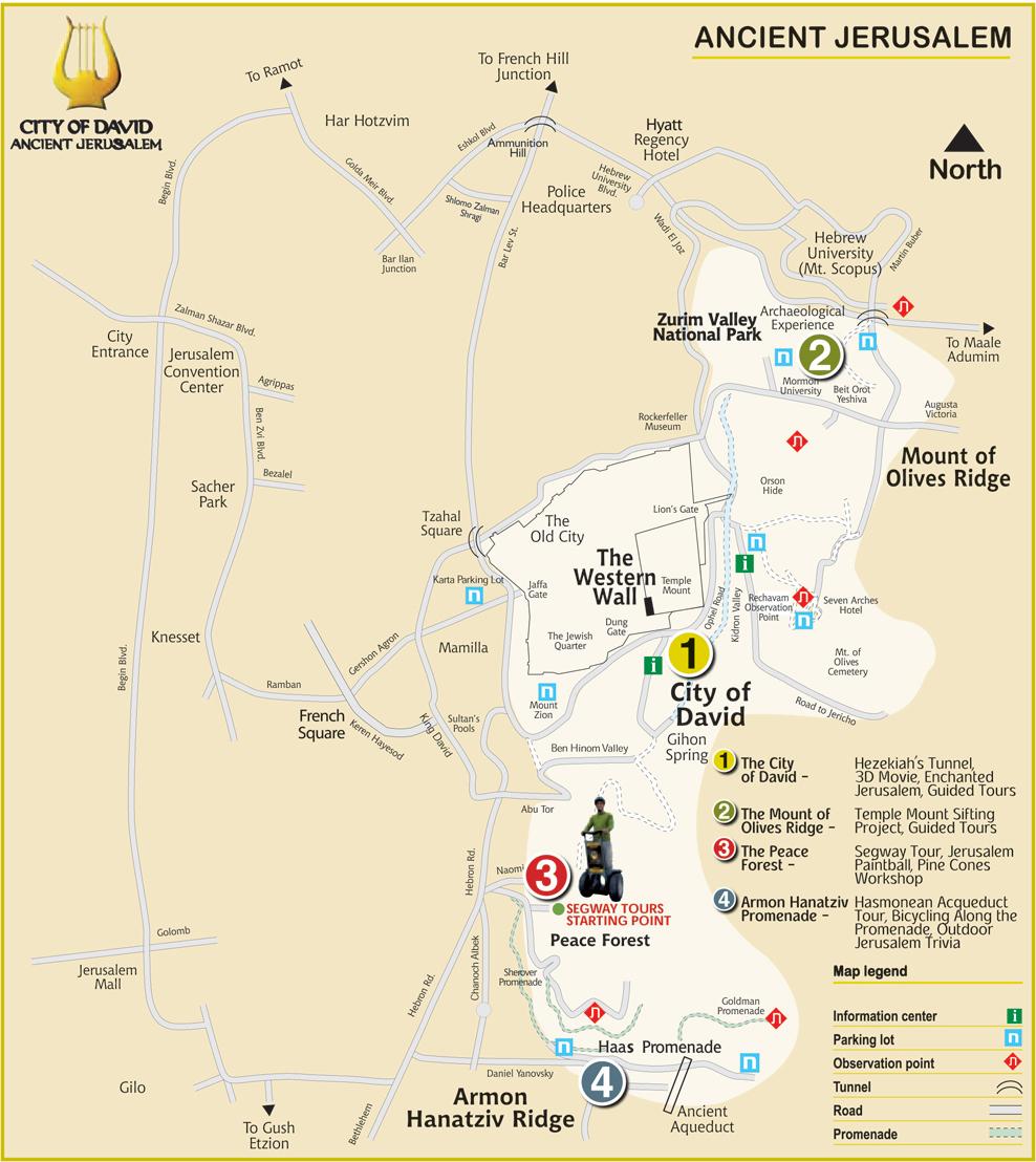
During the Middle Bronze Age, as early as the 18th century BCE, a massive wall was built around the city, of which a 30 m as its shown in the city of David map. long section has been exposed above the Kidron Valley. Within this wall buildings were excavated, indicative of city life during that period. Finds of the Late Bronze Age (1600 - 1200 BCE) are few and disappointing. This is in marked contrast to the common view of Jerusalem as an important Canaanite urban center, based on mention of the king of the city of Jerusalem in the 14th century BCE archive found at Tel el-Amarna in Egypt. In Joshua 10, the defeat of Adonitzedek, king of Jerusalem, who led a coalition of five Amorite kings, is described. Defeat but not conquest: Jerusalem is later mentioned as a Jebusite city (the Amorite and Jebusite peoples were part of the collectively known “Canaanites”) in Judges 19:10-12.
During the 13th-12th centuries BCE structural operations changed the topography of the upper part of the city: interlocking and intersecting stone walls created terraces which provided an artificial surface, apparently the podium of the citadel of the Canaanite-Jebusite city of Jerusalem as its mentioned in the city of David map. During the excavations, Warren Shaft (named for Ch. Warren, an English archeologist who pioneered systematic excavations in Jerusalem between 1864-67), the earliest water system of the City of David was cleared. This underground system, constructed at the end of the second millennium BCE, enabled the citizens of Jerusalem to draw water from the Gihon spring without leaving the fortified walls of their city. A recent geological survey has shown that Warren Shaft incorporates a number of geological features which give credibility to the assumption that it was functioning even before David's conquest of Jerusalem and may be the tzinnor (Hebrew for pipe or conduit) mentioned in 2 Samuel 5:8.