search
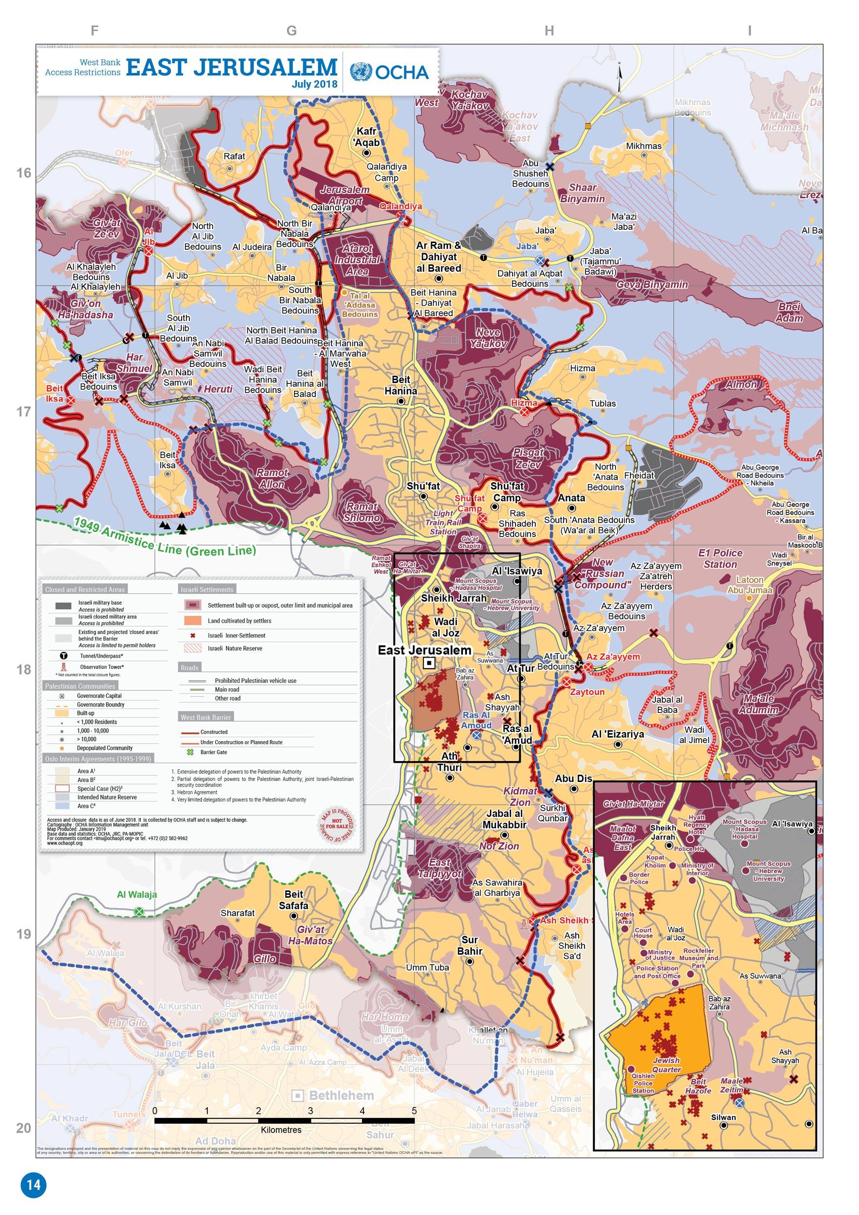
East Jerusalem map
Map of east Jerusalem. East Jerusalem map (Israel) to print. East Jerusalem map (Israel) to download. The term East Jerusalem sometimes refers to the area which was incorporated into the municipality of Jerusalem after 1967, covering some 70 km2 (27 sq mi), while sometimes it refers to the smaller area of the pre-1967 Jordanian-controlled part of the Jerusalem municipality, covering 6.4 km2 (2.5 sq mi) as its shown in east Jerusalem map. Foreign tourists, embassy workers and some Jewish Israelis mill among East Jerusalem largely Palestinian Muslim neighbourhoods. Several well-trodden religious and archaeological sites are here, though some visit purely to experience the rhythms of daily life: busy bakeries, market stalls and the hypnotic sound of the muezzin call to prayer, louder here than elsewhere in the city.
Outside the Old City Damascus Gate is Jerusalem mostly Arab neighborhood of East Jerusalem. Just to the east of the gate, within the gardens at the foot of the wall, is Solomon Quarries, a cave system that extends under the Old City as you can see in east Jerusalem map. According to ancient tradition, the stone for Jerusalem First Temple was quarried from here. The cave is also known as Zedekiah Grotto as in Jewish tradition, Zedekiah, the last king of Judah, hid here from the Babylonian forces in 587 BC. Slightly east from here (along Sultan Suleiman Street) is the Rockefeller Archaeological Museum. Inside are exhibits from the Stone Age right up to the 18th century. If you are short on time, some of the highlights of the collection are the skeleton unearthed on Mount Carmel, known as the Carmel Man, in the South Gallery, the 6th-century BC Lachish letters in the North Gallery, and the ornately carved beams from the Al-Aqsa Mosque in the South Room.
If you walk down Nablus Road, you will come to the Garden Tomb, which dates from the Roman or Byzantine period. It was found and identified as Christ tomb by General Gordon in 1882, and some Protestant Christians still believe that this is the true site that Christ was buried and rose again. Heading north along Nablus Road is the French Dominican Monastery of St. Stephen, where its namesake, the first Christian martyr, is believed to have been stoned to death as its mentioned in east Jerusalem map. Veer off onto St. George Street from here, and you will come to the site of the Mandelbaum Gate. Between 1948 and 1967, it was the only crossing-point between the Israeli and Jordanian sectors of Jerusalem. The site is marked with a plaque. Also on St. George Street, is the Museum on the Seam, a one-of-a-kind (in Israel) contemporary art museum that exhibits works dealing with social commentary on human rights and conflict.