search
Jerusalem light rail map
Light rail Jerusalem map. Jerusalem light rail map (Israel) to print. Jerusalem light rail map (Israel) to download. The Jerusalem Light Rail (Harakevet Hakala) stretches from Pisgat Ze’ev in the North (Heil Ha’avir Station) to Mount Herzl in the West, with many stops along the way. The first line of the Jerusalem light rail system is 13.8 kilometers long as you can see in the Jerusalem light rail map. Currently the line connects the neighborhood of Pisgat Ze’ev, in the city’s north, with Mount Herzl by way of the city center, and it includes 23 active stations and 3 park-and-ride lots. Extensions of the line are planned to Neve Yaakov neighborhood in the north and Hadassah Ein Kerem Medical Center in the south, as part of the J-Net project.
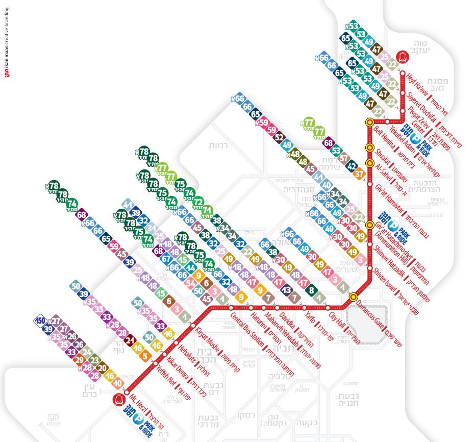
The Light Rail line begins at the Mt. Herzl stop near the Bayit ve-Gan neighborhood, the National Cemetery, and the Yad VaShem museum as its shown in the Jerusalem light rail map. From there, it continues along Herzl Boulevard and travels up onto the Gesher HaMeitarim (the Suspension Bridge, literally "Bridge of Strings"), that stretches over the main city entrance; the bridge was built specially to enable the Light Rail to pass above the street-level and the numerous transportation lanes below. The line continues down to Yafo Street and passes through the Central Bus Station and the colorful Mahane Yehuda market. From there, it continues along the Yafo pedestrian street, which was built for the Light Rail and city center pedestrians; it reaches the City Hall stop next to Safra Square, from where you may access the Old City and the Mamila Mall. From City Hall, the line continues through Tzahal Square to the Damascus Gate, to the area of the hotels on Route 1, to Ammunition Hill, and French Hill Junction.
The Jerusalem Light Rail Red Line, the first in Israel, passes through the heart of the city and connects its neighborhoods to the city center as its mentioned in the Jerusalem light rail map. The Light Rail connects between the different regions of Israel capital and makes the trip accessible for the city entire population. As part of the Red Line plan, a solution was needed for connecting Jaffa Road with Herzl Boulevard at Jerusalem entrance intersection, where traffic is heavy. The bridge solution was chosen, rather than an underpass, because of the route of the existing tunnel where Begin Boulevard passes beneath the intersection. Due to the project urban characteristics, it was decided to build a cable-stayed bridge planned by the world renowned architect, Santiago Calatrava.